Apologies to the Pointers Sisters given, and hopefully accepted!
The Bravo/Tojo crew has headed into the Outback, in a big way. Leaving Alice Springs, we headed out to drive the iconic Canning Stock Route. (Oh yes we can, can....)
 |
| Remains of Len Beadell's original supply truck, abandoned after a fire |
But to reach the Canning, we first needed to drive the Gary Junction Road, originally put in in the 1960's by Len Beadell and his crew as part of the Woomera nuclear testing range. The GJR is approximately 1000km of remote gravel, all on aboriginal land (permits required), linking a couple of remote villages and seldom traversed by us "white fellas", as we're known to the indigenous inhabitants.
 |
| Typical Gary Junction Road scenery |
The GJR traverse proved to be "no drama", really. The surface was firm and fast, even though fairly badly corrugated in places. Camping was prohibited in the first 400km stretch of road, so after a bit of a long day, we entered the aboriginal village of Kintore, where we had heard camping "might be available". The woman who pumped our diesel told us about an area out in the bush known as the Kintore Marbles, famous for beautiful rock formations and sunsets, about 12km down another dirt road, and she said we should be fine camping out there, even though our permit clearly prohibited us from camping anywhere but right along the GJR. The village was very poor, as are all of the indigenous villages, and signs advised travelers to keep on going, and not to stay in Kintore. But it was getting late, we were eager to make camp, so headed deeper into the desert to make camp for the night.
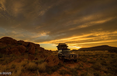
After several dead end roads and washouts, we eventually found the Marbles, and what a great campsite it proved to be. Remote, wild, off the beaten track, with gorgeous scenery and a terrific sunset to cap it off.....Kintore proved an unexpectedly great stop!
Wild dingos wandered by our camp, curious but keeping their distance as they gave us the hairy eyeball. A bit unnerving at first, but they've proven to be relatively harmless visitors to many of our desert camps.
 |
| Typical dingo encounter |
And so it went on the Gary Junction Road, driving several hours each day, and camping along the roadside. We rarely saw another car, though one sped past us and threw a gravel rock into our windshield resulting in a large spreading star.....bastard!
Camels were a common sight along the road, both dead and alive.
Brought over from Afghanistan in the 19th century for transportation and exploration of the western Australian outback, the animals are now considered a feral nuisance. With over 1 million of the rascals roaming around the country by 2008 (and expected to double every 8 years), the government began a "management program". Today over 300,000 still cruise the outback, degrading the grazing lands and sacred Aboriginal sites. Australia has the largest feral camel population of any country in the world.....no kidding!!!
You definitely don't want to hit one of these "ships of the desert" cruising along at 80 kph, as I don't think the "roo bars" on the front of Tojo would help out much!!!
Thankfully most of our camel encounters were much happier occurrences than that with the poor guy shown above. One night, while drifting off to sleep in our high roof top tent, we heard a loud, slobbery, 'brrrrrrrr-aaaaa-ppppppp-hhhhhhh', right outside the tent window. Turned out to be a camel flapping his lips as he walked through camp!!! Took a while to get to sleep after that!
 |
| Cindi gets water at Jupiter Well on the GJR.....and yes, the nights were C-O-L-D until we worked our way north |
 |
| Plaque and register to sign at the intersection of the Gary Junction Road w/ the Canning Stock Route |
The Gary Junction Road eventually intersects the Canning Stock Route close to it's midpoint, in the Aboriginal community of Kunawarritji. Our trusty guidebook ("Australia's Top 100 4 Wheel Drive Adventures"), the bible of Outback adventure travelers, describes the Canning:
"The Canning Stock Route is the most demanding 4WD route in Australia. There are drives that are rougher, sand dunes that are taller, and floodways that are stickier, but no track compares with the CSR in terms of sheer distance and the mechanical and physical endurance required. Vehicles must be in top mechanical condition and capable of carrying enough fuel.....
Vehicle and crew preparation is vital and weight must be minimized. Speed is the enemy of reliability, so take it easy on the CSR and drop tyre pressures in the soft sand to reduce mechanical stress."
In short, the CSR was calling out to the intrepid Bravo/Tojo's.
So just what is this bad boy of Aussie 4x4 travel all about, anyway? Well, it's actually just what the name says, a stock route through the desert, not really a road at all. As originally laid out in 1906 by Alfred Canning, a surveyor with the Western Australian Department of Lands and Surveys, the CSR was a way to drive cattle from the Kimberly cattle stations in the north down to the Kalgoorlie goldfields. Canning returned in 1908 to locate wells approximately every 25-30km, in order to water the cattle. Many of these original 51 wells are now in ruins, but several have been refurbished and provide a reliable source of water to travelers of the route.
Obviously the CSR traverses Aboriginal lands, and old Canning was a nasty bastard in his dealings with the original indigenous owners of the land. He captured and abused many of the locals to get them to show him possible well sites, and as a result, the local people understandably made things rough on the cattle drovers. A pattern of attacks and reprisals took place, including well poisonings and killings, and by 1930 only 8 "mobs" of cattle had been droved the length of the trail, a 5 month journey. By the 1950's, only 20 mobs had made the trip, and sea and eventually truck transport took over as the more economical methods of moving cattle long distances.
 |
| Sign at the end of the Canning Stock Route tells the sad story of its development. |
So, what was the journey like for us? Well, first of all, Tojo, our trusty Land Cruiser, was the perfect tool for the job. We had no mechanical failures of any consequence, not even a flat tire. A good thing, too, as really, "failure is not an option". In case of a serious breakdown, vehicle recovery costs on the CSR typically run around $15,000. We carried an HF ham radio, as well as an EPIRB emergency satellite beacon, but happily neither was needed for an emergency.
We did see several old burned out vehicles along the route whose journeys obviously came to a less happy conclusion.
 |
| Remains of an old Ford Explorer |
 |
| Motorcycles have also tried the Canning.......some were successful |
The track conditions varied greatly. Some days crossed continual sand dunes. Only by reducing tire pressure down to about 20-22 psi were we able to make it up the dunes, sometimes needing our low range gearing.
Happily for us, especially in the area of sand dunes, traffic was very sparse. (At one point we went 2-1/2 days without seeing another vehicle!!!). Nonetheless we kept a "sand flag" flying on the front bumper to get greater visibility should a rig be approaching from the other side of a dune, and we gave a call on our UHF CB radio (approx 25 km range) about every 30 minutes to alert any opposing traffic that we were heading south.
Here's a bit of video of some of the dunes......some were harder than these, a few easier, NONE were boring!!!
https://vimeo.com/177886659
Other parts of the trail were deeply corrugated wheel tracks, and it was all we could do to keep Tojo in a sweet speed spot to avoid cracking molars. At a fast enough speed you sort of skip on top of the corrugations, minimizing stress on us and our gear.....but it could be hard to hold the speed and keep on the road!!! Therein lies the challenge!!!
 |
| Up one dune, and on to the next...... |
Often we camped at the old well sites. Some provided water (which we treated or boiled before using), others just a bit of an oasis.
 |
| Flock of finches enjoy the water at a CSR well |

One afternoon we came upon a beautiful pool of fresh water, out in the middle of the desert, known as Breaden Pool, where supposedly the drovers enjoyed a cool soak on the trail.

A short hike brought us to Godfrey's Tank, where several of the cattlemen etched their names and initials into the sandstone surrounding the pools.
We passed thousands of these termite houses, made of what else, termite shit. Some were big and easy to see, others might be small, sharp, and hiding right at the side of the track, waiting to pop a tire.
 |
| Trump Tower, Aussie style!!! |
Old graves could be found at a few wells.......the wording on the tombs told a harsh tale.
Some wells reminded us of a scene out of Breaking Bad, a favorite TV show.....Walt and Jessie would feel right at home here!
Finally it ended. The track wound up in the Aboriginal settlement of Billiluna, a short distance from Halls Creek. While we were glad to come out safely, get a chance for an ice cream and to refuel and reprovision, there was certainly a part of us that was sad to see this adventure finish.
While some of the scenery was dramatic in it's immensity, it was the incredible remoteness which made the CSR travel both unique and magical. Driving for days without meeting anyone else, sharing camps with only dingos, camels, birds and bugs, and experiencing the incredibly clear, beautifully dark skies of the outback nights made this trip such an amazingly unique experience.
Next up.....on to the Kimberly, with the Bungle Bungles and the Gibb River Road.....stay tuned!


